| Programme of EventsMembershipPublicationsEditorial BoardOfficers | Library |
|
|
Hampshire Field Club & Archaeological Society |
| Registered Charity number 243773 | HomepageArchaeologyHistoric Buildings LandscapeLocal History |
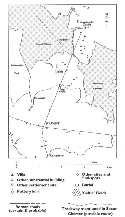
Newsletter 43 - Spring 2005 Romano-British and Saxon Commons: The evidence from Leigh, Havant John Pile The mediaeval hamlet of Leigh occupied a ridge of gently rising ground between 70 and 100 feet (21 and 30 m) above Ordnance Datum. To the west the tributaries of the Hermitage Stream drain the clay lands of Havant Thicket; to the east lies the valley of the Lavant Brook; and to the north the ground drops steeply to Durrants and Redhill. Havant, until recently a small market town, lies on the coastal plain, about 1½ miles (2.5 km) to the south. The site of Leigh, which had been occupied intermittently since Mesolithic times, was provided with a reliable supply of water both from shallow wells sunk into the gravels overlying the impermeable London Clay, and from the springs that issued from the junction between these two geological formations.[1] Leigh also benefited from the varied resources offered by the many soil types and contrasting locations within its surrounding area.[2] Leigh lies on the London Clay at the extreme eastern edge of the Hampshire Basin. The London Clay together with the sands and clays of the Reading Beds immediately to the north, comprise the underlying geology of the Forest of Bere and its surrounding commons. These mainly damp and heavy clays provided the timber and underwood required for building, for agricultural equipment, fences and gates, and the fuel for domestic and industrial purposes. The extensive common wood-pastures also provided pannage for pigs and grazing for cattle and horses. Although often difficult to drain and to bring into cultivation, the more tractable areas of the London Clay close to the settlement yielded arable land of a reasonable quality, but most of the common arable fields lay on the valley gravels immediately to the south and east of Leigh. The water meadows along the valley of the Lavant Brook provided both rich pastures and the important hay crops in their respective seasons. All these resources were available to the tenants of Leigh as part of the Bishop of Winchester’s manor of Havant, but beyond these limits to the north lay the South Downs, the lower slopes and valleys of which provided good crops of wheat, barley and rye, whilst the chalk hills were sheep country par excellence. The landlord and tenants of Leigh may not have benefited directly from the produce of the country beyond its manorial boundaries, but the valley of the Lavant formed a natural route by which some of this produce would find a market in Havant. The origins of the mediaeval hamlet and tithing of Leigh are difficult to determine. The earliest known documentary reference to la Lye, OE lēah, occurs in 1236, but as lēah means both ‘wood’ and ‘clearing’, its sense in this instance is uncertain. Margaret Gelling has demonstrated that the element lēah was sometimes used as a habitation term with the meaning of a settlement in a woodland environment,[3] and Richard Coates agrees that Leigh may have been the ‘clearing-settlement’ within a tract of ancient woodland.[4] As lēah was in use as a name-forming element at least since the 7th century A.D. and continued to be used to form place-names well after the Norman conquest, the place-name alone is of little value in determining the origin of the settlement.[5] Two Anglo-Saxon charters of 935 (S 430) and 980 (S 837) contain almost identical boundary clauses defining an estate that was probably very similar in extent and outline to the post-Conquest manor of Havant and, subsequently, the ecclesiastical parish.[6] The Anglo-Saxon bounds skirt the site of Leigh, but it would appear from the descriptions of the boundary points in this area that although we are in a generally wooded environment, we cannot be far from a settlement. Two trackways are indicated: the ‘eastern highway’, apparently running north-westward towards Horndean from somewhere near Redhill (possibly the (on) Lamhyrstæ of the charter), and the ‘straight way’ (S 837) or ‘ridgeway’ (S 430) running southward from Rowlands Castle to Whichers Gate. The hedge (or enclosure) of the Iwwara, ‘the people of the yew’, may refer to part of Idsworth tithing; and (on) herredes leage,‘(to) Herred’s wood or clearing’ probably lay to the north of Bartons Cross, either on the Warblington side or the Havant side of the boundary. The lid geat, ‘swing gate’, was probably in the vicinity of the BUPA hospital in Bartons Road and it may have been the entrance to the common pasture from the arable land to the south. This identification is supported by the fact that subsequent boundary marks are individual trees, which are less likely to have been used for the purpose in a wooded environment. A similar transition from open to wooded country occurs on the western side of the Anglo-Saxon estate where the bounds move from an open to a predominantly wooded environment to the north of Stockheath, the present common being a ‘relic’ exit-funnel from a block of common pasture that stretched across the estate from one side to the other.[7] This impression is strengthened by the fact that Leigh Green appears to have been another former exit-funnel issuing from the common pasture into a droveway now represented by New Lane. A continuous stretch of common pasture may therefore be envisaged extending west from Emsworth Common to include Bedhampton Park, which was probably formed by Hugh de Port, the lord of the manor of Bedhampton in 1086.[8] The exit-funnel from the park, which is clearly indicated on the Bedhampton tithe map, was probably a feature of the pre-Conquest common. If this interpretation is correct, it suggests that this area of common wood-pasture was the lēah, the woodland site of the mediaeval hamlet of la Lye, and that the settlement had not been founded by 980 A.D. The inconclusive nature of the place-name evidence for the foundation of Leigh has already been mentioned, but the fact that 95 sherds of pottery from an excavation close to the centre of the settlement were dated by Chris Currie to the 12th to 14th century seems to support the view that it may have been in existence by c.1200 A.D.[9] References to Leigh in the Winchester Pipe Rolls; post-mediaeval court rolls, and estate maps enable some twelve villein messuages and twenty cottagers holdings to be identified, although possibly not all were occupied at any one time. The 1665 hearth tax assessment confirms this general picture as there were then twenty-four dwellings in the tithing of Leigh containing a total of fifty-three hearths.[10] The hamlet survived until the early 19th century (although it was probably shrinking by this time), when Sir George Staunton sealed its fate by buying out the remaining freeholds and copyholds to enlarge his park and create a model farm. Only a few properties were suffered to remain where they did not impinge on Sir George’s grand design.[11] During the Romano-British period, a settlement, the ‘proto-Havant’, developed on the 1st century road from Chichester to Winchester via Wickham where it passed close to the Homewell spring. This development was followed by the construction of a branch road from the centre of Havant to Rowlands Castle, and possibly another to Hayling Island via a wadeway across the Langstone Channel.[12] The settlement at Havant occupied an ideal position for a market centre dealing in salt, fish, shellfish and wildfowl from the sea and marshes to the south; grain and market garden produce from the fertile coastal plain; cattle, pigs and hides from the forests and wood-pastures to the north; pottery from the Rowlands Castle kilns, and wool and sheep from the Downs beyond.[13] Figure 1 shows the known Romano-British sites in Havant and Leigh, the distribution of which is clearly related to the roads. The villas at Langstone and Bedhampton have been excavated, but that at Warblington is known only through chance finds.[14] Many of the other finds, especially those of pottery and building materials, must also indicate occupation of some kind. A site at Oak Park by the side of the Lavant Brook and close to the branch road from Havant, for example, was excavated in 1992 and revealed several ditches and associated 2nd and 3rd century pottery.[15] Further north and also on the branch road a concentration of sites and find-spots occurs at Leigh where the site of a Romano-British farmstead was excavated in 1968 and 1970.[16] Further north still, close to the road and the Lavant Brook, at Mays Coppice Farm, an extensive pottery production site, probably in use between the late 1st and the late 3rd centuries, has been known for many years. Recent studies by Ian Hodder, following some excavations by Margaret Rule in 1963, demonstrated that the coarsewares were distributed both to villages and farmsteads in the Downs around Chalton, and to Fishbourne and Chichester and its hinterland.[17]
When the sites and find-spots to the north of Havant are plotted on a map of the commons prior to their enclosure in the 19th century, a remarkable distribution pattern is revealed. Not one of the Romano-British sites occurs on common land, but each of the two groups – the Leigh group and the Rowlands Castle pottery group – fits neatly into its own area of ‘assart’, one to the north and one to the south of a narrow strip of ‘waste’ joining Havant Thicket to Emsworth Common. It is difficult to avoid the conclusion that these clearings were formed from an area of more extensive wood-pasture in Romano-British or earlier times. The fuel for the pottery kilns was probably obtained from managed coppices in the vicinity of the site, and the establishment of these may have contributed to the initial clearance of some woodland. The ‘assart’ containing the Leigh group of sites may have a more complex history. As I have attempted to show, this appears to have reverted to secondary woodland after the period of Romano-British occupation, to be opened up again after the Norman Conquest. It is difficult, if not impossible, to demonstrate continuity of occupation on any archaeological site, particularly from the Romano-British period to Saxon times. Margaret Gelling has argued convincingly for the survival of a sub-Roman population at Havant based upon the etymology of the place-name, but this population may have been limited to the main settlement.[18] It is more difficult to demonstrate continuity of institutions such as transhumance and commoning practices. Perhaps such practices occurred independently at different times in response to similar circumstances. The evidence from Leigh may not bring us any closer to a solution for these problems, but it does suggest some interesting possibilities, and suggestions for future research. A consideration of the evidence suggests similarities between the agricultural regime of Leigh in the Romano-British period and that of the Middle Ages. The wood-pastures of the Forest of Bere would undoubtedly have been exploited during the 1st to the 5th century, probably in much the same way as they were in Saxon and Mediaeval times, and such an extensive area as this must surely have been intercommoned by the surrounding settlements. The proximity of the Romano-British farmstead at Leigh to the wood-pastures of the forest; the arable lands to the south; and all the other components of a viable agricultural unit suggest that the choice of site was determined by the same considerations that supported the mediaeval hamlet of Leigh. Although there is no suggestion of continuity of occupation at Leigh between the Romano-British and Saxon periods, the place-name evidence considered above leads us to suspect that the site of Havant continued to be occupied, and the wood-pastures to the north continued to be grazed, throughout this period. Acknowledgement I am very grateful to Dennis Turner of the Surrey Archaeological Society for his helpful comments on the first draft of my article. It was particularly valuable to have the benefit of Dennis’s innocent eye – so far as my chosen patch is concerned – and, hopefully, I have been able to render several obscure passages more intelligible. Any remaining obscurities, errors of fact, and errors of interpretation, are the fault of the author. Notes and References
|
||||